Strengthening Flood Risk Management Induced by Climate Change in Stung Sen River Basin, Cambodia
ABOUT PROJECT
The main goal of the project is to improve flood risk management through integration of technical and institutional linkage into policy, and reducing vulnerability of local community livelihoods.
OBJECTIVE
To reach the project goals, three different objectives must be achieved as follow:
· Assess the physical and hydrological conditions, flood frequencies and future trends in rainfall patterns within the river basin and assess how these might influence future flood risks in the river basin induced by climate change
· Identify the flood impacts on community’s livelihoods both men and women and social institutions
· Assess the institutional mechanisms and institutional capacity gaps addressed to strengthen flood risk management in the Stung Sen River Basin.
OUTPUT OF THE PROJECT
· Flood risk assessment improved through integrating modelling and social approaches
· Capacity built on flood risk management and adaptation to climate change provided to local government and communities.
· Policy brief and research paper published on Integrating Institutional and technical approaches to improve flood risks management and adaption in the context of climate change.
STUDY AREA
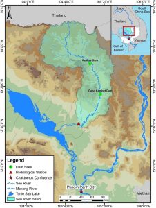
Sen River Basin is located in the northern part of Cambodia and covers two provinces namely Preah Vihear and Kampong Thom. The total area of the basin is about 16,000 km2, which lies between latitudes 12°30′ and 14°30′ North and longitudes 104°00′ and 105°30′ East (Chung et al., 2019). The Sen River originates from a high elevation in the mountainous area of Dangrek, Cambodia-Thailand border, and flows for about 500 km to the southeastern end of Lake Tonle Sap. The drainage area of the basin is divided into three sections: an upper reach (more than 370 km from the lake), a middle reach (370–230 km from the lake), and a lower reach (within 230 km of the lake).
The climate in Sen River Basin is dominated by tropical monsoons with two distinct seasons. The wet season is from May to October and the dry season is from November to April. The basin receives approximately 1,400 mm of mean annual rainfall, and the minimum and maximum annual rainfall are 1,104 mm and 1839 mm, respectively. According to Nagumo et al. (2010), the minimum and maximum monthly average water discharges from 1982 to 2000 at Kampong Thom station were 9 m3/s and 702 m3/s, respectively. The water level typically reaches 13 m during the rainy season, nearly double the dry season level of 6 m; whereas the discharge fluctuates from 10 m3/s in the dry season to 700 m3/s during the rainy season (Nagumo et al., 2013). The major land cover in the basin is forest, which covers 85.37%, while agricultural land accounts for 14.41%, and urban land occupies 0.02% of the total area (Oeurng et al., 2019)

